The Labyrinth Navigation System
If the "Lighting-hypothesis" of the Berlin architect and historian for buildings Klaus Kürvers is true: Yes. Together with the Berlin photographer Jürgen Hohmuth he is working in a project documenting labyrinths on the coast of Sweden and the investigation of a hypothesis on their nautical function. The "Torch-theory" is represented in a book of Jürgen Hohmuth: Labyrinths and Mazes, as contribution by Klaus Kürvers in the chapter The Riddle of the Troytowns. More about the book at Labyrinth books on this website, and at www.zeitort.de ... Link > You can read the hypothesis also in a downloadable article in English with the title Labyrinth and Seafaring at www.zeitort.de, projects > labyrinths ... Link > Here are some topics of the hypothesis on the nautical function of the "Cretan labyrinth pattern". The Troytowns directly situated at the coast served as nautical beacons when lighted by torches or lanterns, thus making them visible from afar.
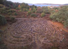
Photo: The Labyrinth of Skallanäs in Sweden (to enlarge click please) Copyright: Jürgen Hohmuth, Berlin, Oct. 2002
The following animation tries to show the Principles and the Application: |
 The
labyrinths at the coasts of Sweden, Finland, and Estonia are
connected with the development of Pilot Stations
in the Middle Ages.
 The
labyrinths show a geographical reference to the orientation
of the goal and the mouth, and the environs. By this a connection
between the form and the function
of the labyrinths may be explained.
  The
figure of the labyrinth could have served as an instrument to
produce controlled nautical beacons. Through
the light it is a help for orientation by showing
the way and by deliverance.